August 12, 2015 12.2 Miles Macalester-Groveland, Lexington-Hamline, Summit-University (Rondo), Summit Hill

This sign is a great summary of how I feel about Summer. Except for the fishing part. How I do love summer-the heat, the humidity, the long hours of sunlight and being outside. Just like a boy, I’m out the door as soon as possible. Summer is fleeting, so often, dinner is a peanut butter sandwich or partially reheated leftovers. This sign on the door is at 1308 Stanford Avenue, Mac-Groveland.
Summit-University

The house at 925 Marshall was undergoing some remodeling when I visited. Supplies from that project drew attention away from the highly ornamented front yard. Gazing balls, or globes, and cement figurines of numerous sizes and shapes made up the majority of the adornments.


Rondo
From 925 Marshall, the heart of the Rondo neighborhood is slightly more than two blocks north.

The small white building at Concordia Avenue and Milton Street doesn’t doesn’t stand out architecturally. However, it’s been a part of Rondo since its construction in 1912.

The lack of identifying signage on the building made it difficult to tell what 334 Milton is. In addition to the address, there are two “No Loitering” signs, single signs saying “No Smoking” and “No Trespassing” and a City of Saint Paul Building Permit. The only hint was the contractor listed on the permit – “Pioneer Lodge No. 1 F And A M.” A quick Google search told me the building is home of Pioneer Lodge No. 1 of the Prince Hall Masons, a traditionally African-American Masonic Lodge.
Pioneer Lodge No. 1 has a long and notable lineage. The group’s website (http://pioneerlodge1.bravesites.com/about) dates the Lodge’s roots to 1866 and goes on to say that in 1907, it assumed the name Pioneer Lodge No. 1 F and A M (Free and Accepted Masons.)

Prince Hall, according to http://www.princehall.org/history.htm, was one of 15 free black men who were initiated as Masons in Boston in 1775. Hall, an abolitionist, was a prominent member of Boston society. He fought for equal rights and opportunities for African Americans in Massachusetts until his death in 1807.

It’s hard to believe the 55 apartments and townhomes of St. Philip’s Gardens were built in 1972. That’s a complement to the splendid renovation the complex, originally built almost 45 years ago by the St. Philip’s Episcopal Church congregation to house the working poor. According to the website of the non-profit Twin Cities Housing Development Corporation, which purchased St. Phillip’s Gardens in 2012, the property was renovated the next year. I haven’t been able to determine whether the development of St. Philip’s Gardens was a response to the displacement of Rondo residents Interstate 94 was built. However, it is plausible since hundreds of homes in Rondo were removed to make room for I-94.


This unusual building, the Rondo Education Center, was the next stop on my eastward ride along Concordia Avenue. The one-time Control Data Corporation World Distribution Center opened in 1978, as the supercomputer firm continued its expansion.

(CDC formed in 1957 when a group of disenchanted Sperry employees left to produce mainframe computers under what they felt was less bureaucratic management.)

Only a few years after the World Distribution Center opened, the computer industry began an earthshaking change – away from mainframes and toward desktops. CDC was among the industry giants that suddenly saw its profits dwindle and then evaporate, ultimately resulting in the sale of this building, and others.

The Saint Paul School District purchased the former World Distribution Center in 1990 for more than $8.4 million. District officials spent another $14.7 million to convert the structure, renamed the Rondo Education Center, into one that housed several schools and district programs.

Although the signs for the Rondo Education Center and its individual schools list the address of the building as 560 Concordia Avenue, Ramsey County records say the official address as 304 Dale Street, the same as when it was a CDC building.
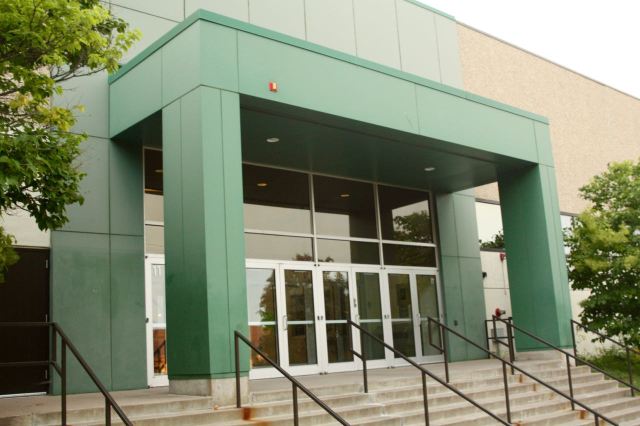

The Rondo Education Center, the largest of all Saint Paul School District buildings, and surrounding grounds span nearly two city blocks.
The Martin Luther King Rec Center, sitting immediately north, shares the property with the Rondo Education Center.


History envelops much of this neighborhood, so a little bit of research uncovers fragments of long-gone events. The Northeast corner of Mackubin Avenue and Carroll Street is one example. McKinley Elementary School was located here from 1903 until 1972.


An unusual sign – to me anyway – hung prominently on the same post that marked the corner of Mackubin Street and Carroll Avenue. It is a remembrance of Captain John Kill, who died on September 4, 1972 fighting what officials believe was an arson fire at the shuttered McKinley Elementary School. The massive blaze required five alarms to extinguish, according to the September 4, 2012 post of the “On Scene with Car 1” blog by Saint Paul Fire Department Chief Tim Butler. Investigators found eight separate ignition points in the building, leading them to strongly suspect arson. Captain Kill and his Engine 18 Company were setting up a water supply when he collapsed. Kill was pronounced dead at the hospital a short time later.
Just two blocks south, at Mackubin and Marshall, is this unusual obelisk-shaped concrete post. Its purpose was a mystery to me. Even with Google I couldn’t figure it out.


This ride is a great example of the mix of old and new one can find around Saint Paul. Sometimes they’re obvious, as with the townhomes built in 2006 at 770 Concordia next door to the single family house 100 years older. Many times, where there is only new, it is photos, recollections and the written word reminding us of the past.
Click here to see a map of this ride.
Another great ride. It’s fun to rea about the history of your city.
Thanks a lot for your support, Nep. I really appreciate you reading and commenting.
Wolfie,
Even though I’ve been now living in the Philippines for the last 5 years St. Paul always was and still i
home. I love your ride posts. It even surprises me how often I say to myself “I’ve been there” when viewing
your posts. Keep up the good, some day years in future someone searching for information about sites in
St. Paul will find your collection of rides an inspiring resource.
David Freedman
Webmaster, The Extra Alarm Association of the Twin Cities
p.s. Former Captain John Kill of the StPFD was well known to me. I was pleased to see
the sign placed regarding him.
Hello from Saint Paul, David. Thank you very much for reading the blog. I’ve used your site, The Extra Alarm Association, several times for posts. The old photos and details are great. Do you have any idea of who is putting up the signs memorializing firefighters who’ve died on the job and for how long? It’s a great tribute.
Best, Wolfie
I’ll see what I can discover about those remembrance signs regarding former members of the StPFD.
Thanks David.
Wolfie don
Regarding those placards commemorating those members of the StPFD who had fallen in the line of duty… It’s the Local 21 Union of the IAFF whoes done it (among others). See http://www.iafflocal21.org/?zone=/unionactive/view_page.cfm&page=Line20of20Duty20Deaths
Hi David. Thanks for following up on this. I looked into the links you sent and will add them to the next post that includes anything related to the SPFD. Since you started investigating the memorial signs I’ve seen two more, most recently on the exterior brick wall of Highland Village Shopping Center, Ford Parkway and Cleveland.
Thanks very much for your insights.
Wolfie
I love your cycling tours, Wolfie! I bike more in Minneapolis and along the river, but I notice the very same things: the odd small building, the bits of public art and remembrances and odd yards. Biking is just the right speed for observing such stuff. Thank you for the short histories you provide! I especially love your map!
Kirk, thanks for checking in again. Your nice comments always motivate me. I appreciate them all.
Wolfie
I’m rather new to SP and have really enjoyed reading your posts. They help me learn about this great city that feels more like a small town. Thx!
Hello Karen. Welcome to Saint Paul! You’ve very nicely summed up how many people feel about Saint Paul, or “Saint Small” as it’s sometimes know. I hope you continue to enjoy the city and have the chance to experience all it has to offer.
Wolfie