I ride around Saint Paul to connect people, places, and stories. Every block, every street, reveals history, culture, and a better way to see the city.
Another nice day for a ride, this time to the northern edge of Saint Paul. The first stop – for a window – came in the St. Anthony Park neighborhood.
St. Anthony Park
One of the gorgeous stained glass window at 897 Raymond Avenue.
Como
Like tulip leaves poking through the soil foretelling spring, signs of the State Fair were showing a month before opening day.
On the edge of a parking lot on the south side of Como Avenue, several State Fair Police cars waited in the shade for the Great Minnesota Get Together to begin.
The police cars were wearing several different livery schemes.
This Crown Vic, a police staple for decades, was decorated in a traditional black and white paint scheme.
This older Ford had a monochromatic charcoal color and different graphics.
And the rare Chevy Impala sported all-white paint with graphics similar to the black and white Crown Vic.
It’s not just the State Fair’s own properties in prep mode for the big event. Nearby homeowners had their own ways of getting ready.
San Francisco has Haight-Ashbury (credited as the place where the counterculture movement began in the late 1960s.) In Saint Paul we get close, with the name anyway, with Hoyt-Asbury.
Asbury Street was named in 1881 for Bishop Francis Asbury, one of the first two bishops of the Methodist Episcopal Church in the United States. So says Don Empson in “The Street Where You Live.” Empson adds that the bishop’s name was attached to the street due to its proximity to Hamline University, which got support from the Methodist Episcopal Church.
The original Chelsea Heights building and Horace Mann Elementary in Highland Park, also a Wigington design, are nearly identical.
Chelsea Heights Elementary School, one of many Cap Wigington-designed Saint Paul school buildings, is two blocks east of Como Park Lutheran, at Hoyt and Huron Street.
The original Chelsea Heights building was built in 1932 and exhibits many of the Depression-era Art Deco accoutrements common to design and construction from that time.
The original part of Chelsea Heights (center), the 1953 (center right) and 1974 (left and right) additions are visible in this picture.
Some creative soul at Chelsea Heights noted the summer break in a fun way.
Larpenteur Avenue is the northern border of Saint Paul in much of the city. The busy Larpenteur/Lexington Avenue intersection is one of many places where Saint Paul and Roseville meet. This corner features strip malls and stand-alone buildings housing mostly national chains. I’ve dubbed this look “Anytown U.S.A.” since it is nearly impossible to distinguish what city you’re in.
One of the coolest looking bars in Saint Paul is Ted’s at 1084 Larpenteur. From the neon sign, to the metal door and the overhang above, this is a gem from a bygone time.
Less than a block east, Larpenteur becomes a residential street lined with single family homes, including the noticeable 968, one of the older houses along the street.
Many of the homes along Larpenteur are of the post-World War II vintage.
Mailboxes and a Little Free Library in the 800 block of Larpenteur Avenue West.
Elmhurst Cemetery, a final resting spot for Lutherans, sits on some 100 acres bounded by Larpenteur on the north, Dale Street to the west, Nebraska on the south and Mackubin on the east.
The northern edge of Elmhurst Cemetery was my first stop in the North End. Elmhurst was established in 1858, the same year Minnesota joined the Union. I didn’t explore Elmhurst but will ride its roads and look at grave markers another time.
The open spaces at Elmhurst are home to an assortment of wildlife.
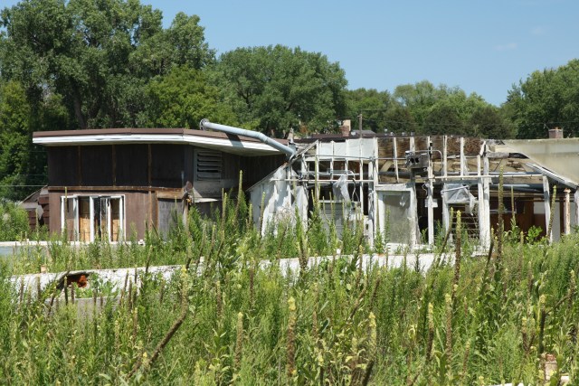
From Elmhurst Cemetery my eastward progression continued for the equivalent of five blocks to a parking lot with an abandoned building.
From outside, it was difficult to tell how long Linder’s had been closed.
One of the few signs I noticed warning people to stay out.
The interior of the one-time Linder’s Garden Center was in rough but recognizable shape.
Linder’s 11 acre property stretched north to south between Larpenteur and Wheelock Parkway, and east to west between Galtier and Farrington Streets.
Concrete pads which may have been covered by greenhouses, perhaps appropriately continued to host flora. Beyond the concrete slabs were fields where Linder’s grew some of the plants they sold.
The former store building looking from the concrete slabs to the south.
Additional land and other buildings on the far south end of the Linder property.
I got back on the bike to check out the southern part of the Linder property. Jumping over to Marion Avenue and taking a right, I immediately spotted an abandoned house at which I stopped.
1674 Marion Street was obviously abandoned.
Realty records indicate that 1674 Marion Street was all of 400 square feet, with one bedroom and one bath. It was built in 1949.
Any interest in a close look at the house disappeared when I noticed the warning on the back door. Muriatic acid, similar to hydrochloric acid, is frequently used to kill and remove mold on concrete, bricks and tile.
On the southern part of the Linder property, along Wheelock Parkway, there was another building and some old greenhouse foundations.
Along Wheelock Parkway on the far south end of the Linder property, more abandoned buildings and growing areas.
These deteriorating buildings at 275 Wheelock Parkway held part of Linder’s wholesale business.
Inside one of the former wholesale buildings.
The remains of one greenhouse and support structures. It is remarkable how quickly nature takes over a deserted place.
The disintegration of the wholesale building is apparent from this view.
Albert Linder picks celery from his field in 1920. Courtesy Pinterest/Sharon Amorosa
More celery from the Linders circa 1935. Courtesy Pinterest/Sharon Amorosa
The last few years that led to the closing of Linder’s Garden Center interrupted decades of growth. Albert Linder started his farm store here next to Wheelock Parkway in 1910 selling celery to restaurants. (I don’t know if that building was still here.)
After spending close to half an hour traipsing through the old buildings and the former fields of Linder’s I got back on the bike and followed Wheelock Parkway southwest to Dale, and Dale to Maryland. There I dismounted for a few shots of the legendary Conny’s Creamy Cone, the North End’s famous soft serve drive-in. No, I didn’t have a cone. On this ride.
There seems to be a line all summer at Conny’s Creamy Cone.
The giant ice cream cone is one of the convivial aspects of Conny’s.
Another is the 24 flavors of soft serve.
Como
From Conny’s it was a short ride to Como Lake, one of Saint Paul’s finest hangouts, no matter what your interest.
It goes without saying (so why did I say it?) that Como Lake and Como Lakeside Pavilion are the two best known features of the park.
Hiking is popular among dogs and their humans. This peninsula, called Duck Point, is on the eastern side of Como Lake.
A handful of stand up paddle boarders meandered around the lake on this nice day.
More than 30 years ago this commemorative plaque was placed on a rock along the walking path that goes past the Como Lakeside Pavilion. The Sterks have multiple connections to Como Park.
Nearby is this stunning flower garden with dozens of flowers still blooming.
Kayak, canoe and other watercraft can be rented behind the pavilion.
There are hangout spots galore here too.
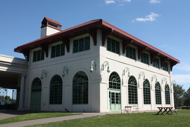
The Pavilion, rebuilt in 1992 based upon architectural drawings of the 1905 structure, is very similar but with updates to accommodate modern demands of a public building.
When this picture was taken in 1906 the original Como Park Pavilion was brand new. Photo courtesy MNHS
The attention to the details, such as you see in the lights, contribute to making the Pavilion such a delightful building.
The Spring Cafe occupies the main floor of the Pavilion, and the second floor can be rented for weddings and other events.
A window reflects a pillar and a section of the roof of the stage area.
A good crowd turned to enjoy this band concert.
Como Park is one of Saint Paul’s largest, finest parks, which provides an exhaustive variety of activities. Therefore, I will need additional rides to properly cover the sites and history of this remarkable park.
Back in St. Anthony, I was getting close to the end of the ride, but the Minnesota Chemical Company building was worth a stop.
The Minnesota Chemical Building was showing some age but its beauty still shows through.
And look at the sign. It’s a gem.
Minnesota Chemical Company opened in 1915 as a supplier of laundry and dry cleaning supplies. MCC manufactured soap products for laundries, dairies and creameries, according to its website. When the laundry industry moved toward synthetic soaps Minnesota Chemical shifted from manufacturing to supplying equipment, parts, and repair service for commercial laundries, dry cleaners and coin-operated laundries.
Minnesota Chemical circa the 1930s in its original building. Courtesy Minnesota Chemical Company
Exploring the shuttered Linder’s Garden Center buildings and property were the most interesting part of this ride. Since then, the property was redeveloped and is now the home of a Hmong language and culture charter school called Community School of Excellence. I’ll make a trip back sometime to see how the school has altered the area.
John, despite the order I posted the pictures, I saw the no trespassing sign after walking through the former store. Still, I would have entered even had I seen the sign first. I have a duty to you and other readers to explore and explain.
As always, I appreciate your thoughtful comments.
Wolfie


Very nice, but San Francisco actually has Haight-Ashbury, not Haight-Asbury, so the similarity is one step less close than you indicated.
Thanks for catching my mistake, Max. I need to replace my current editor and hire you.
I like that the first picture after the no trespassing sign is a picture from the interior of one of the buildings. Well done!
John, despite the order I posted the pictures, I saw the no trespassing sign after walking through the former store. Still, I would have entered even had I seen the sign first. I have a duty to you and other readers to explore and explain.
As always, I appreciate your thoughtful comments.
Wolfie
Wonderful pics, loved the art deco school.