 July 31, 2012
9.1 miles
Mississippi River Boulevard is the western-most road in Saint Paul. The River Road as it is often called, starts at Saint Paul’s northern border with Minneapolis and meanders south through the neighborhoods of Desnoyer Park, Shadow Falls, Macalester-Groveland and Highland Park where it ends at its intersection with Shepard Road. On tonight’s ride I covered the northern half of Mississippi River Boulevard, traveling north from Ford Parkway. Despite living only half a mile from the River Road, I saw some new things and took the time to more completely experience others.
Popular with walkers, joggers and bikers, paths paralleling the road overflow with people when it’s nice and are void of pedestrians only in the harshest weather.

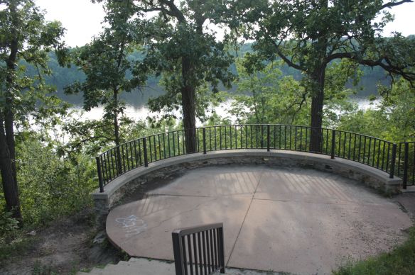
Through the years the City of Saint Paul has done quite well providing access to green space adjacent to the River Road, overlooking the Mississippi River. Thanks in part to planning by landscape architect Horace Cleveland in the late 1800s and early 1900s, there is much public space featuring scenic vistas, benches and art in addition to walking and biking paths.

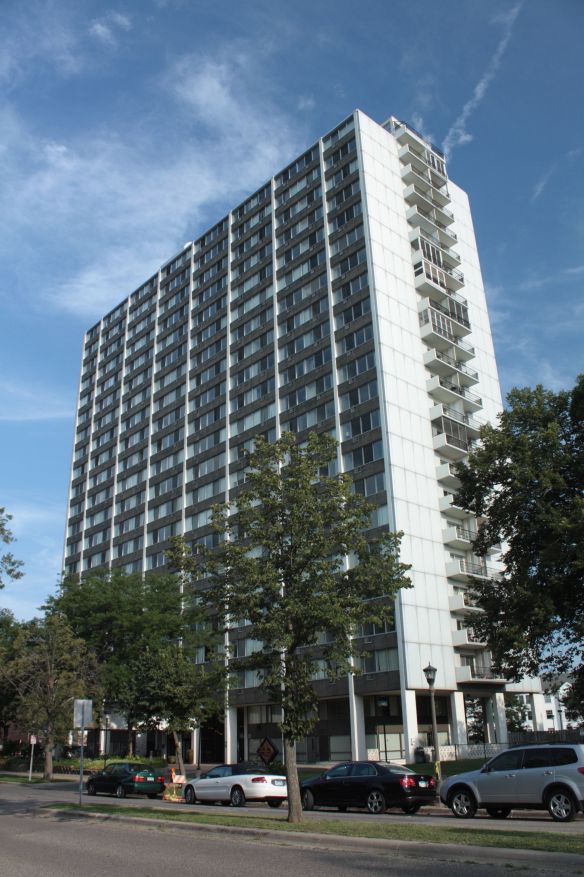 The 740 River Drive Apartments, at Mississippi River Boulevard and Highland Parkway, tower over the area. The 23-story building was put up in 1961 and though it is so unlike anything else along the River Road, somehow it doesn’t look out-of-place. One oddity is the name, as there is no River Drive anywhere in Saint Paul.
 Today, a high-rise like 740 in a neighborhood like Highland Park would draw such indignation from area residents that a developer would have to be delusional to even propose it.

Just north of 740 is one of two houses of worship which line Mississippi River Boulevard. This Christian Science Church has its main entrance on Highland Parkway but also borders River Road.

The Temple of Aaron, a Conservative Jewish congregation, is about four blocks north on the corner of River Road and Hartford Avenue.
Stately homes line Mississippi River Boulevard. Many were built in the 1920s and ‘30s but I would guess homes have been put up in every decade since the turn of the last century. These two houses are just north of Randolph Avenue.


These two brick dwellings on either side of Princeton Avenue aren’t twins-more like a couple of siblings with an unmistakable family resemblance.

I’ve been infatuated with both for years and still debate with myself as to which one I like better.


As I followed the River Road past north past Summit Avenue I heard the unmistakable resonance of running water. I pedaled onward and the street turned to the east then, an eighth of a mile further, made a horseshoe curve back to the west. There, on the edge of some thick woods, I spotted a sign and next to it, a pathway into the woods.

I could faintly hear the running water again and decided to investigate by cruising back toward where the sound first caught my ears. I locked my bike, grabbed my camera and followed a path into the woods. Before long I came upon Shadow Falls for the first time. I knew the neighborhood near here was sometimes referred to as Shadow Falls but never really knew why. Not much of a falls really, but considering the dry summer, I was surprised there was any water flowing.

I followed a path toward the falls and heard the rustling of something moving through the brush. Coming my way was a dog and several yards behind, his master.
The man introduced himself as Peter Herzog (and his English Cocker Spaniel Bess). We spoke about Shadow Falls area. He told me it is a good place to fossil hunt and proceeded to demonstrate by picking up several small ones.
Peter wanted to snap a couple more photos before the sunlight faded so we agreed to meet in 10 minutes for a formal interview. Later, he told me, “What I like about this time of day is the light quality and I look for things that are back-lit like those leaves and flowers. I think I got some nice shots.”

I mentioned that as I hiked the path near the Falls I noticed trash, primarily beer bottles and cans, which Peter called commonplace, “That’s something that is very discouraging Every Friday, Saturday Sunday morning trash, broken bottles. You have to look past it because it’s always there.”
Peter still described Shadow Falls is his favorite place to walk, “With the dog, you have a reason to get out every day and this is such a wonderful place to go. I’m interested in nature. And as you can see I carry a camera. When you have a camera with you, you start looking more intently and you think what’s photographical here.”
Peter’s favorite time of the year to shoot around Shadow Falls is “in the winter, right after the snow I love to go down there when there’s no tracks. It’s so beautiful.”
Shadow Falls and the surrounding area have an interesting history. It was a busy tourist spot as early as the 1870s, frequently visited by hikers, folks picnicking and Mississippi River tour boats.


If not for the influence of noted landscape architect Horace Cleveland, a resort proposed in the 1880s may have been built near the falls. Instead Cleveland urged officials of Saint Paul and Minneapolis to safeguard the Mississippi River bluffs for public use. Shadow Falls officially became a park in 1902, three years after Archbishop John Ireland donated 18 acres of land between Summit and Marshall Avenues to Saint Paul.
Moving on from Shadow Falls, I made a quick detour to Exeter Place.


During tonight’s ride along Mississippi River Boulevard, I was surprised to discover some memorials to loved ones who have passed. The first marker I spied, in remembrance of Laura Wegner-Hay, was near the sculptures in the 600 block. Laura Wegner-Hey, one-half of a set of twins, died prior to her birth in 1996 while her twin brother lived. Laura’s parents apparently continue to live in the Highland Park area of Saint Paul.
 The second commemorative plaque, memorializing Tony Basta, is less than a block north of the intersection of Randolph and the River Road.
 The innocuous look of the memorial for Tony Basta belies the awful circumstances of his death. Tony, 17 years old, was riding his bike along Mississippi River Boulevard about 10 p.m. on April 26, 2000 when he was shot at random by three lowlifes in a car who were looking for someone to kill. Tony died a short time later at Regions Hospital. Another remembrance of Tony is a short distance from the bench with the plaque.


Finally, at River Road and Pelham Parkway, I saw this plaque in honor of Edward Leete. Edward Leete was a professor of organic chemistry at the University of Minnesota. and according to his obituary, loved running along River Road. Dr. Leete lived about a block from the River Road, on Otis Avenue.
 Emerald Street-the border of Saint Paul and Minneapolis and where Saint Paul’s Mississippi River Boulevard becomes Minneapolis’s East River Parkway.
 The competition between Minnesota’s two largest cities plays out, perhaps accidentally, quite visibly here through an assortment of signs. It’s obvious that Saint Paul wins this skirmish and barely breaks a sweat.

People entering Saint Paul along the River Road from the north see this.
Here’s the view from virtually the same spot, but from the south into Minneapolis.

Thanks to technology, I was able to capture this last series of photos though the sun had set. Still, darkness was coming fast so I put the camera away and was homeward bound.
http://www.mapmyride.com/routes/view/158803081
Your posts teach me so much about the town I live in, Wolfie. Have lived in this neighborhood for a long time, and have never seen Shadow Falls. Definitely a destination in the near future!
Thanks for reading the blog and commenting!
________________________________
I used to live at 72 Exeter Place. “The woods across the street” was my little slice of nature in the heart of the city and would play along those paths in the sunken woods nearly every day as a child. It wasn’t until recently that I learned of the formal name to my little secret play land, Shadow Falls.
I enjoyed your journey along the boulevard, a place very near and dear to my heart. Thanks for sharing!
Hello Jill.
Thank you for reading the blog. I appreciate the great recollections of your childhood in “the woods across the street.” When is the last time you were there? Where do you live now?
Thank you again.
Wolfie
I believe that Abigail Van Buren (Dear Abby) lived at 740 many years ago.
Paul, how did you find out about Abigail living at 740? Do you have any other details?